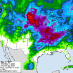
Temperatures dipped below freezing earlier this week as spring perennials started forcing their way out of their winter slumber. Forecasts over the next few weeks are suggesting temperatures should be above normal. Does this mean no more snow is likely for the season? Can we start putting away our snowplows and make space for our…Read more about Is the snow behind us?[Read More]
Beth Hall

The last week has caused many to struggle with whether to turn the heat on inside. Mornings have been quite chilly, and I am guessing several readers may have also struggled with the decision to wear a jacket as they started their workday. These are tough decisions, no doubt. Several data sources have suggested we…Read more about A false sense of autumn[Read More]
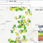
The Midwestern Regional Climate Center (MRCC), with support from the United Soybean Board, has launched the Ag Climate Dashboard — a centralized digital hub offering streamlined access to integrated climate and agricultural data and decision-support tools for producers, advisors and researchers in the Midwest. Designed to support on-farm decision-making, the Ag Climate Dashboard offers up-to-date weather data, National Weather Service…Read more about New Ag Climate Dashboard makes climate resources more accessible for Midwest farmers[Read More]

One heat wave down, more to come. It is summer, though, so aside from expecting plenty of hot days, the things to be more concerned about is reference (or potential) evapotranspiration (ET) significantly exceeding precipitation that would ultimately cause drought-related impacts. The National Weather Service provides a 7-day forecasted reference ET product as well as…Read more about More heat on the way[Read More]
Welcome to the start of Hurricane Season that runs from June through November each year. Why would Indiana care about hurricane season? Certainly, by the time any hurricane might impact the state, it will have been greatly downgraded to what is called an extratropical (i.e., poleward of the Tropic of Cancer (23.5° north latitude)) storm…Read more about It’s a Hazy Shade of … June[Read More]
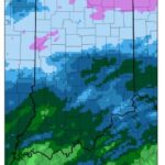
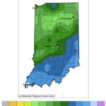
The last few weeks have been on the drier side, particularly for northwestern and west-central Indiana (Figure 1). While temperatures have been seasonal, they are still gradually increasing as we approach summer. Therefore, evapotranspiration rates are starting to increase. This has resulted in the U.S. Drought Monitor classifying much of northern Indiana as Abnormally Dry…Read more about A Bit of Rain Coming Our Way[Read More]
Indiana has already experienced several tornadoes this year with more certainly to come. Of course, this is not unusual since Indiana is often considered on the far northeastern edge of “Tornado Alley”. Tornadoes get their energy from the battle between the cooler, drier Canadian air moving southeastward and the warmer, more humid air coming north…Read more about Tracking Tornadoes Over Time[Read More]
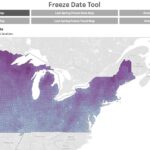
While our daytime highs across the state were in the upper 70s, our nighttime lows have been in the 30s (even into the upper 20s) in some places. This could get us thinking about the timing of the first frost and freeze events of the season, when the 7-day average 4-inch soil temperature falls before…Read more about A chill is in the air – online tools for monitoring and climatology[Read More]
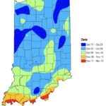
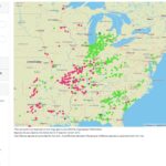
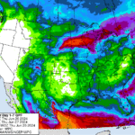
While our entire state did not receive the amount of rain from the remnants of Hurricane Helene compared to other states, most of Indiana did receive at least an inch of precipitation over the past few weeks with some southern counties receiving over five inches (Figure 1). General impacts have been greener lawns (don’t put…Read more about Remnants of Helene helped to improve drought conditions across Indiana[Read More]
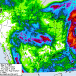
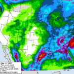
After a period of hot and humid weather where heat indices reached triple digits in some locations, we welcome cooler than normal temperatures for the next several days. It is still summer, though, so sweaters, mittens, and scarves will not be necessary! There were a few temperature records broken over the August 5-6, 2024, period,…Read more about Cooler Temperatures Should Settle in for a While[Read More]
Several weeks ago, Indiana received enough rain to eliminate drought across the state, leaving behind just a few counties in Abnormally Dry (D0) status. Fortunately, this week has been relatively quiet, allowing many areas to alleviate flooding issues. The U.S. Drought Monitor kept those Abnormally Dry areas nearly the same this week (Figure 1), so…Read more about A break before more rain[Read More]
As I write this article, in a cool, air-conditioned office, I hear others talking about how hot it is outside. I see weather app icons showing bold suns that stress how sunny and hot conditions are and will continue to be. I read Special Weather Statements, issued by the National Weather Service, about an extended…Read more about Hot and Dry Conditions Ahead[Read More]

There was an interesting conversation among drought experts this week about how best to communicate drought, particularly when surface conditions appear so saturated. I thought of Indiana a lot during this discussion because with all the rain the state has received over the last several weeks (over twice the normal amount!), there is localized flooding,…Read more about Wet conditions continue[Read More]

An old saying predicts that March will go out “like a lamb”. Another saying predicts April’s wetness with “April showers bring May flowers”. A lot seems to have happened across Indiana since April began, but March finished the month with below-normal rainfall (except for the northern counties) and above-normal temperatures. Does this describe conditions that…Read more about As the sayings go… (Climate & Weather)[Read More]

Since early June, Indiana has been seeing abnormally dry and moderate drought conditions gradually expand and intensify across the state. Conditions peaked in early July when over 94% of the state was classified as either Abnormally Dry (D0; 55% of Indiana) or Moderate Drought (D1; 39% of Indiana) according to the U.S. Drought Monitor (USDM). …Read more about Rainfall helping to eliminate drought across Indiana[Read More]

On the third Thursday of every month, the national Climate Prediction Center releases their 3-month climate outlook for temperature and precipitation. These outlooks are presented as the level of confidence (i.e., probability of occurrence) for conditions to be above or below normal. Since last fall, these outlooks have been consistently favoring above-normal temperatures and precipitation…Read more about Cool and wet conditions now predicted over next few months.[Read More]