As September begins, we officially welcome meteorological fall. While the autumnal equinox isn’t until September 22, the past few mornings have already brought a crisp, fall-like feel to the air. Around town, fall decorations are starting to appear, and a few maple trees are showing early hints of color. My wife, however, is eagerly waiting for me to make the dreaded trip to the attic to fetch our own decorations. This weekend, many of us may see temperatures that don’t rise above the 60s, a refreshing change from the 90°F+ heat we endured just last week. Despite these cooler temperatures, dry conditions have set in across the state and look to continue.
August brought slightly below-average temperatures to Indiana, with a preliminary statewide average of 73.1°F, which was 1.2°F below normal. Temperature swings were notable throughout the month. At the Indianapolis International Airport, highs exceeded 90°F on seven days, compared to the historical average of just over three days above 90°F for the period (1931-2024). Interestingly, the airport also recorded a slightly higher-than-average number of days with highs below 80°F.
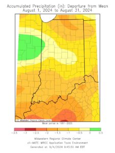
Precipitation levels were below normal for most of Indiana, with a preliminary statewide average of 2.81 inches, which was 1.48 inches below the norm. The largest deficits were seen in northeastern and southern Indiana, where rainfall totals were up to 2 inches below normal (Figure 1). Central Indiana fared better, with precipitation totals closer to the average. Notably, WASHINGTON 1.5 NW in Daviess County reported just 0.87 inches of rain, an astonishing 2.25 inches below normal for the month. In contrast, CAMPBELLSBURG 8.4 NNE in Washington County recorded the highest rainfall in the state, with a total of 7.15 inches.
- Figure 1: August 2024 accumulated precipitation represented as the departure from the 1991-2020 climatological average.
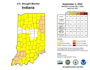
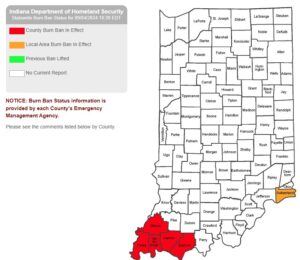
This week’s drought monitor indicates widespread abnormally dry (D0) conditions, with some areas experiencing moderate drought (Figure 2). Currently, 18.14% of Indiana is in moderate drought (D1), while 90.01% of the state falls under either the D1 or D0 category. Rapid dry-down of crops, declining streamflows, and dormant lawns and pastures are becoming common sights in the affected regions. Several counties in southern Indiana are beginning to implement local burn bans (Figure 3).
- Figure 2: September 5, 2024 release of the US Drought Monitor.
- Figure 3: Indiana Department of Homeland Security Statewide Burn Ban Status Map.
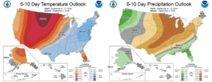
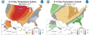
Looking ahead, the Climate Prediction Center’s outlook for September 9-13 suggests that cooler temperatures and below-normal precipitation are likely to continue (Figure 4). However, the 8–14-day outlook shows elevated chances for above-normal temperatures and continued below-normal precipitation (Figure 5). It seems drought conditions may persist through much of September.
- Figure 4: The Climate Prediction Center’s 6-10 Day Temperature and Precipitation Outlook, valid September 9-13.
- Figure 5: The Climate Prediction Center’s 8-14 Day Temperature and Precipitation Outlook, valid September 11-17.
