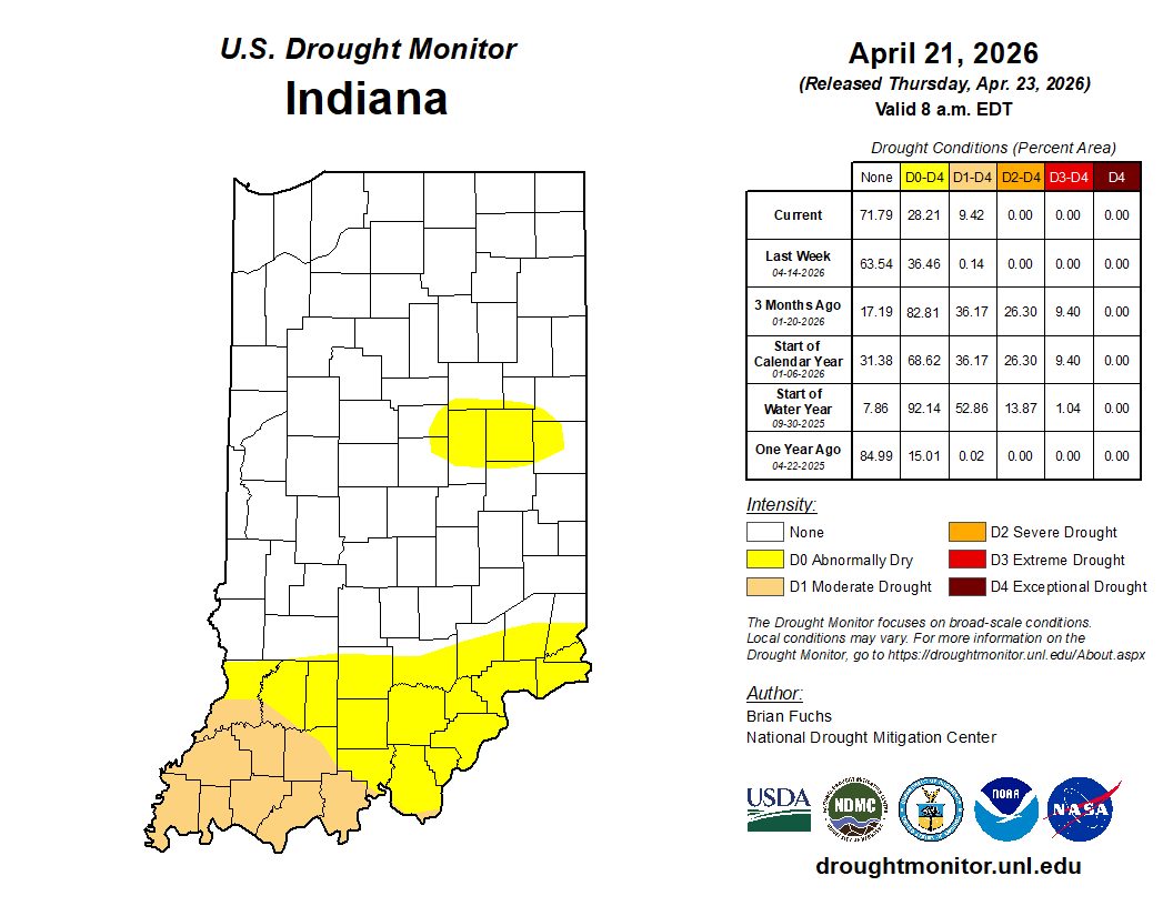
For at least 100 straight weeks (since mid-July 2024!) counties in north-central Indiana (from about Newton and Benton counties in the west to Allen, Adams, and Jay counties in the east) have been in some level of dryness. While not all these counties have been impacted, at least some of them have been anywhere from Abnormally Dry (D0) to Extreme Drought (D3) according to the U.S. Drought Monitor every week. At that most dry-free point in July 2024, there was some abnormal dryness in parts of Jay and Randolph counties (eastern Indiana) as well as some dry areas in the Vermillion-Parke-Vigo county region (western Indiana) and southeast eastern counties spanning from Dearborn into Jackson counties. This drought “minimum” lasted about a month and then conditions started drying out again and hasn’t stopped until this week. That is quite a long time! Because of the recent spring rains, we are once again “almost” dry-free in this area. Only the Madison-Henry county area is labeled as Abnormally Dry in that region (Figure 1). Unfortunately, southwestern Indiana is starting to worsen with some Moderate Drought conditions developing. When was our entire state devoid of any US Drought Monitor category? Answer: April 23, 2024, through June 11, 2024. Yeesh! Will Indiana see a return to that status again this spring? Of course, just because the state is without drought or abnormal dryness doesn’t mean things are great. This could be because conditions have swung too much to the wetter side! This has historically led to delayed planting, plant disease, or other negative impacts. Let us hope for more ideal conditions and fewer extremes!
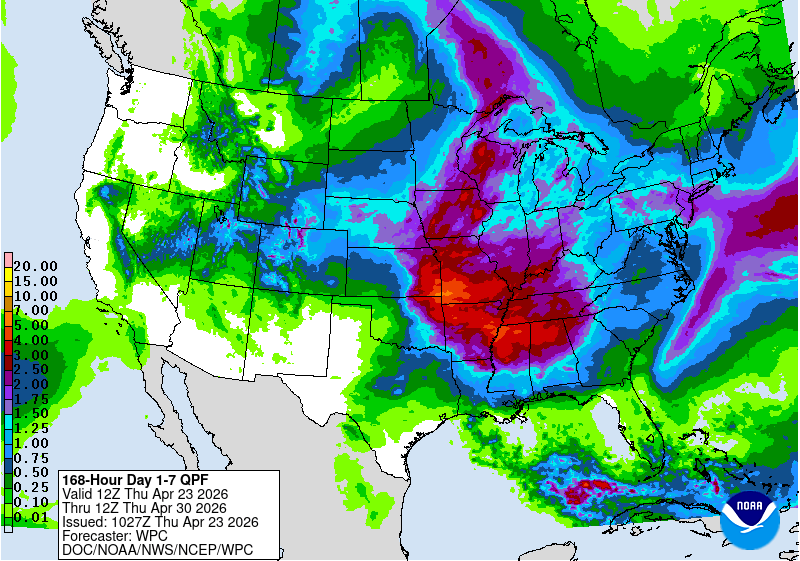
Our 7-day precipitation forecast (through the morning of April 30th) is predicting more spring rainfall ranging between 1.25”-3” with greatest amounts favored in southern Indiana (Figure 2). It looks like this should be spread over multiple days which should hopefully improve drought conditions in southwest Indiana and keep drought from developing elsewhere. Temperatures for the rest of April are favored to be near normal with cooler-than-normal temperatures entering our area as we transition into May. It is still too early to know if those cooler temperatures will carry a risk for frost or even hard freezes, so stay alert and possibly think twice before planting annual flowers everywhere!
-
- Figure 1. U.S. Drought Monitor classifications for conditions through April 21, 2026.
-
- Figure 2. Accumulated precipitation (inches) forecast for April 23-20, 2026. Source: National Weather Service.