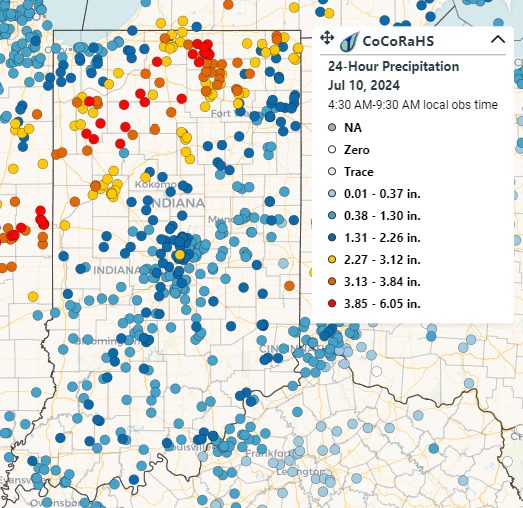
The remnants of Hurricane Beryl brought much-needed rain to the state, although some areas experienced excessive totals. In addition, sporadic power outages were reported as a result of wind gusts exceeding 30 mph. The Community Collaborative Rain, Hail, and Snow (CoCoRaHS) volunteer network once again proved essential, with observations ranging from just under 0.4 inches to over 6 inches. The heaviest rainfall was recorded in northwestern Indiana, where Rensselaer 6.2 SE measured 6.05 inches on the morning of July 10 (Figure 1). Despite Hurricane Beryl being the earliest Category 4 and Category 5 hurricane on record, it was not the earliest tropical system to impact Indiana. In fact, it was the seventh earliest tropical system to reach Indiana, based on data from the National Weather Service Indianapolis Office. The earliest known tropical cyclone remnants to reach Indiana were from Alberto on May 30, 2018.
-
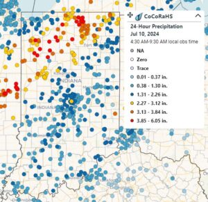
- Figure 1: CoCoRaHS rainfall reports as of 9:00 AM EDT July 10, 2024.
Beryl’s rain came at a crucial time (recent dry conditions and crops entering reproductive phases), as the July 4, US Drought Monitor showed that just over 71 percent of the state was in either abnormally dry (D0) or moderate drought (D1) conditions. Over 17 percent of the state was truly in drought status, classified as at least D1. Southern Indiana experienced some relief in the first week of July, leading to improvements in the July 11 US Drought Monitor (Figure 2). However, drought expansion was noted in the east-central portion of the state, and D0 conditions were introduced in far northwestern Indiana.
-
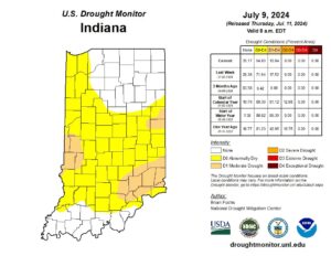
- Figure 2: July 11 US Drought Monitor Map.
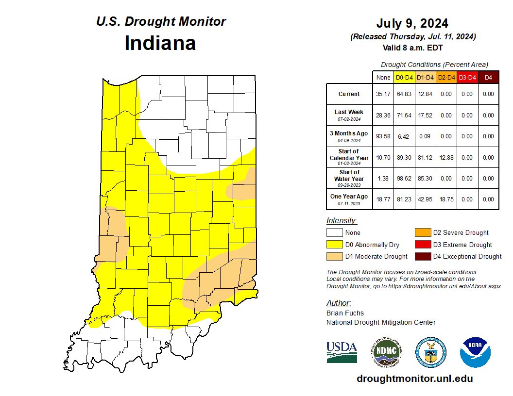
Some of you may wonder why there wasn’t widespread improvement in the US Drought Monitor this week, despite Beryl’s precipitation. The reason is that data collected after Tuesday morning are not considered in the current week’s map. Since Beryl was mostly a Tuesday to Wednesday event, most of the precipitation fell after the cutoff to be considered. We’ll have to wait until next week’s release on July 18 to see the full impact.
Temperatures have been near to slightly below normal across the state since the beginning of July. Despite this, Modified Growing Degree Days (MGDDs) have continued to track above normal since the beginning of the growing season (Figure 3). GDDs have run 100 to 200 units above normal from April 1 to July 8.
-
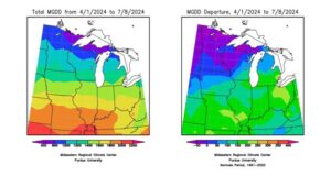
- Figure 3: Left – Accumulated Modified Growing Degree Days (MGDDs) (base 50F, ceiling 86F) from April 1 – July 8, 2024. Right – Accumulated MGDDs from April 1 – July 8 represented as the departure from the 1991-2020 climatological average.
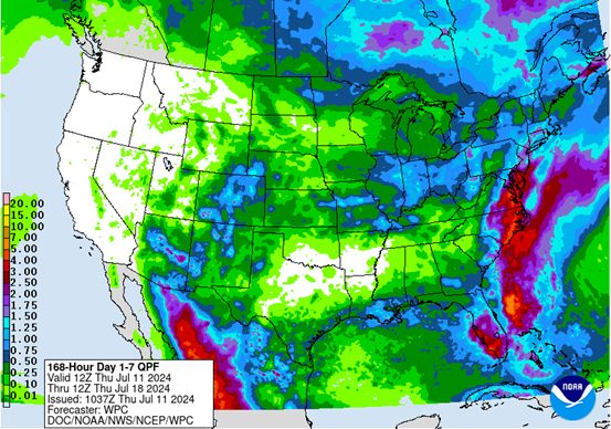
Looking ahead, the Climate Prediction Center indicates elevated chances of near- to above-normal temperatures and precipitation through mid-July. From now until July 18, most of Indiana could see up to an inch of rain, with isolated areas receiving higher amounts (Figure 4). Rainfall is expected to follow the typical summer pattern of scattered storms, where some areas might receive rain while nearby areas remain dry. Statewide, there may be an increased chance of rain toward the end of this forecast period.
-
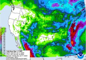
- Figure 4: Weather Prediction Center’s Quantitative Precipitation Forecast valid Thursday July 11 – Thursday, July 18.