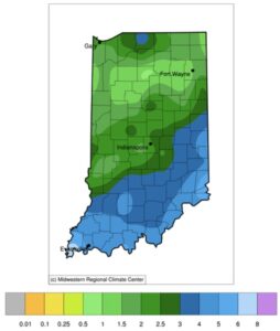
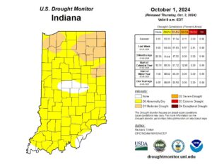
While our entire state did not receive the amount of rain from the remnants of Hurricane Helene compared to other states, most of Indiana did receive at least an inch of precipitation over the past few weeks with some southern counties receiving over five inches (Figure 1). General impacts have been greener lawns (don’t put that mower away, yet!) and wetter soil moisture percentages. Shallow soils (within 20 inches from surface) were very dry prior to these rain events so they either soaked up much of the moisture or were initially struggling to absorb it. As a result, hydrological responses such as rising pond, stream, and aquifer levels have been slower to respond, causing most of Indiana to still be in some state of dryness according to the U.S. Drought Monitor (Figure 2). Forecasts and climate outlooks are not favoring any more significant precipitation for quite some time so expect local conditions to dry out again. The rate of dryness may be slower than during peak summer due to daytime high temperatures gradually decreasing as our length of daylight hours shorten. However, winds tend to become more variable throughout the autumn season due to the battle between the colder air masses from the north and the warmer air masses from the south. Our weather systems currently seem to be coming more from the west, which also leads to less humid air in addition to less crop vegetation to transpire its own moisture. Therefore, due to the windier conditions and less humid air, the environment is more likely to dry out faster even though temperatures will be gradually cooling.
- Figure 1. Total precipitation accumulated from September 19-October 2, 2024.
- Figure 2. U.S. Drought Monitor status for Indiana as of October 1, 2024.
Temperature outlooks are expected to be near normal with slight confidence of warmer-than-normal temperatures near mid-October. Updated climate outlooks for all of October (released on September 30th) provide no guidance regarding temperatures overall being either above or below normal with moderate confidence that precipitation is likely to be below normal.

