Pattern changes, like the one we’ve experienced in the middle of the month, are quite typical for August. The humidity decreases a bit, the soils dry out, and sometimes, like we’ve recently experienced, the temperatures drop quite dramatically. It can be refreshing and exciting for Fall lovers to experience some crisp, cool air in mid-August.
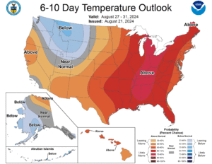
That being said, it’s always too soon to rule out more summer heat—especially when the National Weather Service’s Climate Prediction Center is forecasting a very likely chance of above normal temperatures for August 27-31 (Figure 1). In fact, NWS HeatRisk, an experimental product developed by NWS, is already forecasting category 2-3, moderate-major heat-related impacts starting Monday, August 26 and continuing through at least Tuesday, August 27. This means those who are sensitive to heat should reevaluate any outdoor work until the heat subsides. And not only is the CPC forecasting above normal temperatures in the near-term, but the monthly outlook for September is leaning toward above normal temperatures for Indiana as well.
- Figure 1: the National Weather Service’s Climate Prediction Center is forecasting with confidence above normal temperatures for the rest of the month of august for Indiana and surrounding states.
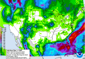
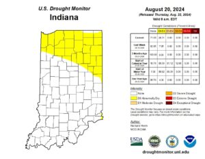
On the flip side, there is almost no precipitation in the forecast across the Hoosier State through the end of the month (Figure 2). It appears that most of the state will receive 0.1 inches of precipitation, at best. While there are currently no drought conditions across Indiana, those with stakes in soil moisture should continue to monitor conditions heading into the drier months, especially since D0 conditions (abnormally dry) have started expanding across northern Indiana (Figure 3).
- Figure 2: Pattern changes mean drier conditions for Indiana through the end of August. At best, the state will see 0.10 inches of precipitation.
- Figure 3: Abnormally dry conditions have been introduced for the northern third of Indiana.
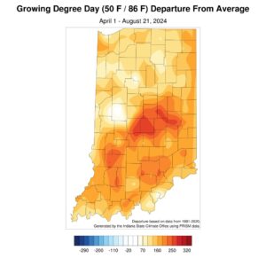
Speaking of soils and agriculture, growing degree days remain above normal across the state. Since April 1, the entire state has been above normal, and in some places by upward of 200-250 units (Figure 4).
- Figure 4: Growing Degree Days continue to remain above normal, even as the season comes to a close.


