As I write this article, in a cool, air-conditioned office, I hear others talking about how hot it is outside. I see weather app icons showing bold suns that stress how sunny and hot conditions are and will continue to be. I read Special Weather Statements, issued by the National Weather Service, about an extended period of hot and humid conditions continuing. It is that time of year, so how hot has it been and how long with these conditions continue?
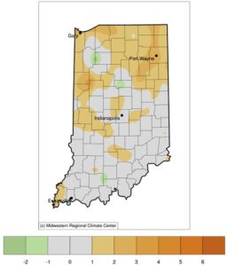
- Figure 1. Average temperature (F) departure from the 1991-2020 climate normal period for May 22 through June 19, 2024.
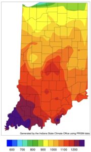
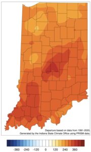
Interestingly, as I look at the last 30 days, most of Indiana has been only one-to-two degrees (F) above normal with respect to average daily temperature with most of that influenced by the daily maximum (high) temperatures as opposed to the daily minimum (low) temperatures (Figure 1). However, something atmospheric scientists call a “heat dome” has moved into our area. These are typically rather large in spatial extent (i.e., regional, not state-sized) and tend to stick around for a while. Due to this stagnation, winds are typically calmer, preventing both vertical mixing of the cooler air above and horizontal mixing from storm systems moving through the area. Growing degree-day accumulations have therefore been increasing faster than normal and will continue to do so over the next few weeks. Figures 2 and 3 show the accumulated modified growing degree days and departures from normal, respectively, since April 15th. Across Indiana, these growing degree days have accumulated over 220 units higher than normal for this time of year.
- Figure 2. Accumulated modified (50 F / 86 F) growing degree days for April 15 through June 19, 2024.
- Figure 3. Accumulated modified (50 F / 86 F) growing degree-day departures from the 1991-2020 climate normal period for April 15 through June 19, 2024.
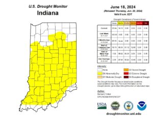
When these stagnant conditions persist, a rapid intensification of drought is more likely. Certainly, an extended period of little-to-no rain will cause a drought but combine that with above-normal temperatures and increased rates of evapotranspiration will occur. That is what has been happening over the past few weeks and has led to the U.S. Drought Monitor introducing “Abnormally Dry (D0)” status across much of Indiana (Figure 4). Another characteristic of these stagnant high-pressure areas is that any precipitation that might occur is likely to be very light and localized. Therefore, widespread improvement is unlikely until this system gets pushed out of the region and a more active weather pattern can set in.
- Figure 4. U.S. Drought Monitor map for Indiana based on conditions through June 18, 2024.
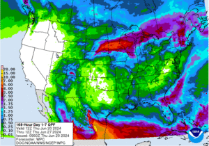
According to the national Climate Prediction Center, there is high confidence that above-normal conditions will continue in our area through the rest of June and into early July. The big question is whether there will be enough precipitation during this period. Climate prediction models are only slightly favoring above-normal precipitation over this two-week period with higher chances early on. Even then, I would expect amounts to be relatively localized and short-lived. The current 7-day forecast of precipitation is predicting only 0.25”-0.5” in southern Indiana with higher amounts for the northern part of the state (Figure 5). Combine this with the 7-day forecast of reference evapotranspiration – that range from 1.5”-1.75” — and there is likely to be a moisture deficit developing quickly.
- Figure 5. Precipitation forecasted amount for the 7-day period from June 20-27, 2024.
