Recent rounds of thunderstorms have brought highly variable rainfall totals across Indiana, continuing a familiar spring pattern of “haves and have-nots” when it comes to precipitation. While some areas have received multiple inches of rainfall over the past week, others have not, allowing dry conditions to redevelop. Heavy precipitation was concentrated primarily from Indianapolis southward, with many locations measuring more than 2 inches of rainfall. Bicknell, located in Knox County, measured 5.33 inches of rain from May 12–19. On the opposite end of the spectrum, Goshen, located in Elkhart County, measured only 0.14 inches during the same period.
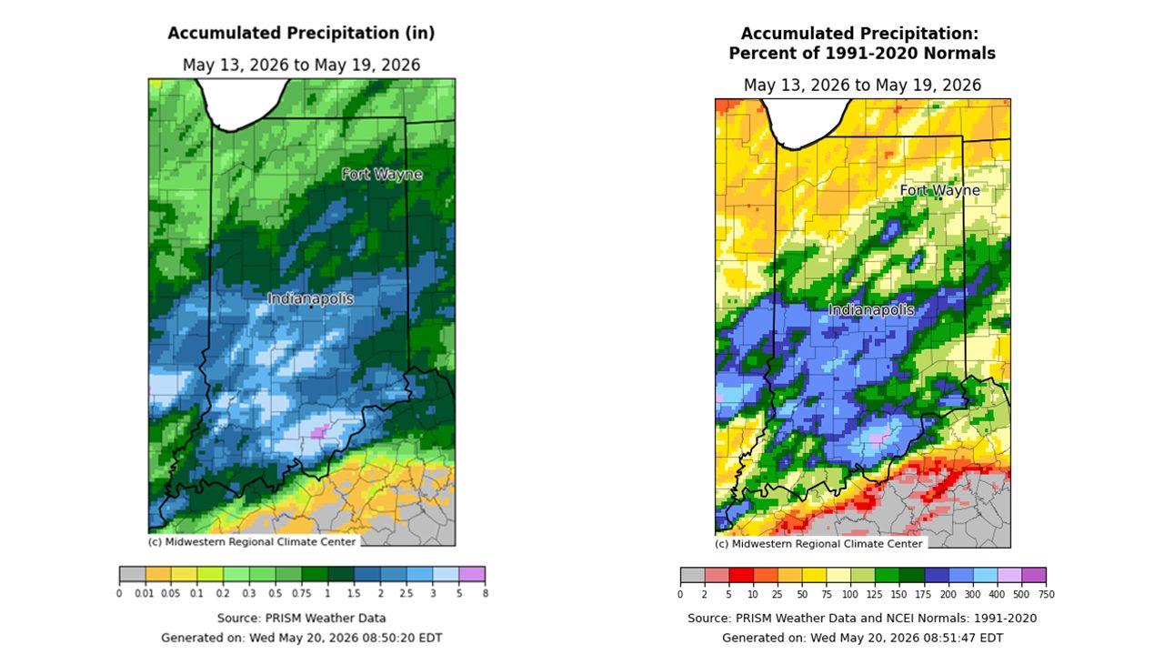
Figure 1. Left – Accumulated precipitation from May 13-19, 2026. Right – Accumulated precipitation from May 13-19, 2026, represented as the percent of the 1991-2020 normals.
This dry trend has continued over the past 30 days across northern Indiana, with some areas receiving between 50 and 75 percent of normal precipitation. Farther south, precipitation has generally been more favorable. Areas from Lafayette through Kokomo and Fort Wayne have experienced near-to-slightly above-normal precipitation overall, although short drying windows have still developed between rainfall events. This has created intermittent planting opportunities across parts of the state, with fieldwork resuming during drier stretches before temporarily slowing again following additional rainfall. Despite these interruptions, planting progress across Indiana remains slightly ahead of normal.
Drought conditions have remained relatively at bay across much of central and northern Indiana in recent weeks. However, abnormally dry and moderate drought conditions have persisted across extreme southern Indiana. Groundwater levels also remain below normal statewide, largely due to the cumulative impacts of persistent drought conditions over the past several years. Streamflows have recovered across much of the state following spring rainfall events, but declines are already emerging in areas that recently missed heavier precipitation, particularly across portions of northwestern Indiana.
Will this pattern hold moving forward? Over the next week (May 20–27), the heaviest precipitation totals are once again forecast to fall south of Indianapolis, where some locations could receive up to two additional inches of rainfall. Meanwhile, much of northern Indiana is expected to receive less than 0.75 inches of rain. This short-term pattern could further improve drought conditions across southern Indiana while also reintroducing abnormally dry conditions in northwestern Indiana.
Looking beyond the next seven days, the Climate Prediction Center continues to favor above-normal temperatures and below-normal precipitation to close out the month of May. Given only a brief reprieve from drought conditions this spring, the potential for rapid drought development is not out of the question, particularly across northern Indiana if warm and dry conditions persist into early summer.

Figure 2. Temperature and precipitation outlooks, produced by the Climate Prediction Center, valid for May 27 – June 2, 2026.