It’s gonna be… I mean… it’s already May! How can this be? Early spring flowers have already cycled through, I’m on record pace for mowing my yard, and field activity has been delayed due to a wet April. April began a bit cool with several mornings having frost advisories and freeze warnings, which was not too out of normal. This cold snap came after a warmer winter and early bud break for many perennial crop producers. We’ve heard reports from north of I-70 that there may not be a peach crop this year. If you experienced frost or freeze damage to your perennial crops, we’d like to hear from you. Kindly drop us an email (in-sco@purdue.edu) so we can document these losses.
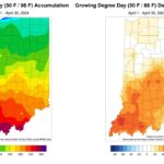
After this cooler start, temperatures rebounded. The Indianapolis International Airport recorded the first 80F temperature for 2024 on April 14. The maximum daily temperature surpassed 80F four times this month, which was more than double the 1931-2024 average (1.8 days). April 1977 had the most days (9) with daily maximum temperatures at or above 80F. Despite the cooler start, the preliminary average temperature for April 2024 was 55.1F, which was 3.7F above normal. Average temperature departures ranged from 2.0F above normal in central Indiana to 4.0F above normal in other areas (Figure 1). As a result of the warmer temperatures, Growing Degree Days ran above normal throughout much of the state (Figure 2).
April was wet. Precipitation totals ranged from 5 to nearly 10 inches across Indiana or 100 to 300 percent of normal (Figure 3). The Indianapolis International Airport had at least a trace of precipitation recorded 19 days throughout the month. This allowed for limited opportunities to get much done outside. Vincennes 4E, located in Knox County, measured 9.6 inches in April, which was 4.71 inches above normal. As a result of the continued wet conditions, the May 2 release of the US Drought Monitor was free of drought for the second week in a row!
The national Climate Prediction Center temperature outlooks favor above-normal temperatures throughout May. Along with this are elevated chances for above-normal precipitation. Not the most conducive to field activity, especially as soils are still trying to dry out. Forecasted precipitation totals exceed an inch statewide, with southern Indiana possibly seeing up to two inches by May 9.
- Figure 1: Left – Indiana average temperatures for April 2024. Right – Indiana average temperatures represented as the departure from the 1991-2020 climatological average.
- Figure 2: Left – Indiana Growing Degree Day accumulations for April 2024. Right – Indiana’s April 2024 Growing Degree Days represented as the departure from the 1991-2020 climatological average.
- Figure 3: Left – Indiana precipitation totals for April 2024. Right – Indiana’s April 2024 precipitation totals represented as the percent of the 1991-2020 climatological average.


